⌫ MEASURE DISTANCE
◆ COPY COORDINATES
☘ SAT PASS — PREDICT PASSES HERE
▣ SCREENSHOT — DOWNLOAD PNG
⧉ SCREENSHOT — COPY TO CLIPBOARD
BRG        RANGE
---°  --- nm
enter speed above
FEED● CONNECTING VESSELS0 UPDATES0 SOURCEAISStream ZOOM-- LIVE0 DARK0 --°N --°E UTC--:--:--
OSINT NAVAL TRACKER
LIVE -- AISStream
0 pins
WX: --:-- UTC

ASG NAVAL TRACKER — QUICK REFERENCE

LIVE VESSEL PLOT

Real-time AIS via AISStream.io. Click any vessel for details, MMSI, IMO, flag, speed, course. Status bar shows feed health, vessel count, dark count, and cursor coordinates. DARK counter = vessels that went silent in the last 24h.

SEARCH

Top-center box. Paste any vessel name, MMSI, IMO, port, or base name. Works across live vessels, ports, wrecks, shipyards, and military bases. Fastest way to act on a news tip.

VESSEL MANIFEST — LIST

Right dock → LIST. Live scrollable manifest of all plotted vessels. Click any row to fly to that vessel. Use WATCH to cycle: ALL → WATCH ONLY → HIDE watchlist. Badges: ⚓ TSP = Tanker Security Program, 👁 SIGINT = intelligence collection vessel, ⚑ SANC YACHT = sanctioned yacht watchlist hit.

LAYERS — SENSOR SUITE

FISHING / SQUID / PRESENCE are GFW heatmaps — 90-day aggregated activity, not live positions. SQUID = squid jigger fleets (Chinese distant-water fleet, visible from space). Overlay SQUID + CABLES to observe proximity to undersea infrastructure. Any cephalopod-cable interaction was almost certainly accidental. Probably.

SATELLITE PASS (SAR) draws live orbital tracks for five imaging radar satellites. Solid line = current pass, dashed = next two orbits. TLE data from CelesTrak, cached 1 hour.

SATELLITE PASS (SPY) enables right-click pass prediction. Check the box, right-click → SAT PASS → select satellites → RUN. Returns next 4 passes per satellite for 24h at minimum 10° elevation. ▶ NEXT row shows time-from-now. Active pass highlighted red. Panel is draggable — grab the title bar to reposition. Footer links to CelesTrak satellite catalog. N2YO API, cached 6 hours.

LAYERS — INFRASTRUCTURE

CABLES — TeleGeography global submarine cable routes. SHIPYARDS — naval and dual-use shipbuilding facilities. RAIL — OpenRailwayMap at zoom 7+. PORTS — global port and anchorage index, searchable.

LAYERS — INTEL ACTORS

INTEL ACTORS — 14 state intelligence arms and proxy entities, 131 documented nodes. Portrait markers with ISO badges. Click any portrait to toggle that actor's spider lines: HQ → Division → Station → Operation. Line weight decreases with each hop. Click any node for type, status, chain, and source citation. KEY button appears bottom-left when layer is active. All data open-source verified.

LAYERS — AOR REQUIRED

DARK — GFW SAR-detected vessels with AIS off. BASING — major military bases in the selected AOR. Enables RANGE RINGS sub-layer for weapon coverage visualization.

AIR TRAFFIC — live aircraft within AOR bounds via Flightradar24. All traffic shown — analyst identifies anomalies. Red = military/gov, orange = unknown/blocked, purple = other. Click aircraft for full card including squawk. Emergency squawk 7500/7600/7700 alerts in red. Refreshes every 30 seconds. The analytical principle: it is not always what is there — it is what should not be there.

RIGHT-CLICK CONTEXT MENU

⌫ MEASURE DISTANCE — click to add waypoints, distance accumulates. ◆ COPY COORDINATES — copies lat/lon to clipboard. ☘ SAT PASS — opens pass predictor (requires SPY layer checked). ▣ SCREENSHOT — DOWNLOAD PNG — saves full map view as timestamped PNG. ⧉ SCREENSHOT — COPY TO CLIPBOARD — same capture to clipboard (Chrome/Edge).

AOR / FLEET FILTER

Focuses map on a U.S. Navy numbered fleet region. Required for DARK, BASING, and AIR TRAFFIC layers. Chokepoint buttons fly directly to operationally significant straits. Vessel legend is permanently displayed below the fleet AOR reference map.

NEWS / WEATHER

NEWS — curated ASG OSINT feed plotted geographically. Read the headline, look at what's in the water around it. WEATHER — RainViewer precipitation radar.

PLOT MODE & REFRESH

SNAPSHOT freezes the plot for analysis. LIVE redraws in real time (zoom 6+ only). REFRESH NOW forces immediate re-sync.

A NOTE ON SAT PASS DURATIONS

Pass durations over ~60 minutes indicate a high-earth-orbit or geostationary object. Treat any duration >60m as a persistent overhead presence rather than a timed window.

You are looking at where every vessel on earth operates — what they operate near — and what happens when they get too close.
FULL DOCUMENTATION
▶ ASG TRACKER GUIDE ▶ SUBMARINE CABLE MAP ▶ WIKIMAPIA
GLOBAL FISHING WATCH — LIVE MAP
CONFIDENCE +
AOR / FLEET FILTER SELECT AREA OF INTEREST
U.S. Navy Fleet Areas of Responsibility
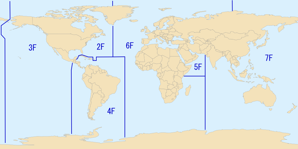
U.S. NAVY NUMBERED FLEET AORs · CLICK TO ENLARGE
◆ CONFIDENCE
LOW — AIS broadcast
SANCTIONED vessel
 WANTED · FBI/INTERPOL
 CARTEL NODE
 CABLE INCIDENT
◆ VESSEL TYPE
Tanker
Cargo
Passenger
Pleasure/Sail
Fishing
Tug/Special
Military
Unknown
LAYERS Overlay intel, cables, threats & activity data
◆ Infrastructure
◆ SENSOR SUITE
◆ Intelligence & Proxy Actors
◆ Criminal Element
◆ AOR Selection Required
◆ Air Surveillance
BASE LAYERS Select the underlying map tile style
SATELLITE VINTAGE — ESRI WAYBACK
Imagery publish date — not the satellite capture date. Applies to the SATELLITE base layer.
VESSEL MANIFEST Live AIS feed — click any vessel to track 0 vessels
Tanker
Cargo
Passenger
Pleasure/Sail
Fishing
Tug/Special
Military
Unknown
GETTING STARTED
▶ IEA ENERGY & AI MAP ▶ SUBMARINE CABLE MAP ▶ WIKIMAPIA
FLYTO CHOKEPOINTS
PLOT MODE
PLOT REFRESH
TIMED 5m
TRACKER INFO ⋮⋮
LIVE 0
DARK 0
ZOOM --
POS --°N
--°E